Hi-Survey is an Android software that is designed for all types of land survey and road engineering projects in the field.
Hi-Survey Road
Hi-Survey Road is an Android software designing for normal land survey and road construction engineering in the field. It is compatible with Hi-Target professional controllers, Android phones, tablets, and other third-party Android devices. It can run on Hi-Target professional controller, general android phone, tablet and other third-party Android devices. Its fashionable and easy to use, supports operating big data with built-in tools.
It is a sleek and easy-to-use software that supports the operating of big data with built-in tools. With customized industrial application solutions, more possibilities are created for users.
Efficient work
An efficient measurement method. When it combined with a professional GNSS receiver and will make your measurement become simple.
Quasi-dynamic survey
A measurement method independently developed by Hi-Target, surveying in some tough areas where there is strong multi-path interference, signal blocking like standing beside the big trees.
Road engineering survey
Using for staking complex roads, combining road lines, and has three road algorithms (intersection, element, coordinate) support all kinds of roads, common line, and multi-type complex lines.
Hi-Survey Features
Integrated with professional road design, road stakeout, and cross-station function, Hi-Sur vey is born to assist sur veyors in efficient work . Driven by Hi-Target’s innovative technologies, Hi-Survey Road
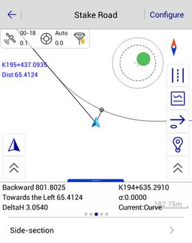
supports multiple road designs, offering Centerline, Profile, Cross-section, Side-section, Broken Chainage and Construction function.
- Hi-Survey Road supports direct import. Users can import road format data or Land XML file from the Road library, which will improve the efficiency of road measurement.
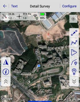
- View the graphic, confirm the location of stakeout points, and stake out a road in the Stake Road.
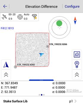
- Survey and store cross-section points in the Store cross-section to get the undulating terrain.
With a hi-tech, fully integrated design, the conveniently sized V90Plus is one of the most flexible choices for any measuring task. Built-in Linux3.2.0 operating system, pre-loaded multiple smart applications such as tilt surveying, electronic bubble calibration, NFC and voice DIY, V90Plus GNSS system provides surveyor industry-leading GNSS solutions. Input data formats supported:
*.txt, *.csv, *.dxf, *.shp, *.dat, *.asc, *.kml, *.NCN, *.geojson
Related Systems:
V90 Plus GNSS RTK System:
Provides a high-performance GNSS measurement operation
V100 GNSS RTK System:
An ultra-compact design, but provides an efficient and reliable surveying solution. V100 is an ultra-compact GNSS RTK receiver with exquisite design and structure. It has multi-frequency full constellation technology, dual-mode Bluetooth and NFC. Provide users with fast, efficient and reliable GNSS RTK surveying solution.
Users can view the number of the tracking satellites, PDOP, Elevation Mask, the current satellite constellations and other information in the sky plot interface. Advanced CAD data management, supporting importing files of DXF, DWG format, and achieving data stakeout by the object snap functions of INT, TAN, PER, etc. DTM surface design, stakeout and earthwork calculation. Convenient cross-projects points selection for stakeout, calculation, etc.. Excellent user experience with device check tools, compass, third-party rangefinders, transition curve calculation, FTP transmission and file coordinate conversation, etc..
Hi-Survey Road is an Android application available under the
Freeware
license — the APK is 25.7 MB.
We’ve catalogued it under
Navigation.
Help fellow users decide. Share your experience with Hi-Survey Road.