Version: 121.0
Application Description:
This Marine Charts App offers offline nautical charts, inland river navigation charts, and lake contour maps for kayaking, yachting & sailing.First marine navigation app to have boat route assistance with Voice Prompts. All features of a Marine Chart plotter in one app!
It supports Nautical Charts course up orientation. Incl Tide Charts & Currents prediction for nautical navigation.
Create new boat routes / Waypoints, or import existing GPX/ML routes on device. Has Marine AIS(NMEA) support.
-FEATURES
GPU accelerated offline vector NOAA charts/ENC charts (text stays upright on rotation)
Lake depth map shading/safety lake depth contours: customize boat safety depth
Maritime Aids to Boat Navigation : Beacons,Buoys,Boat Launch areas,Boat Ramps,Marina, Fishing Attractors etc
Record marine tracks, Autofollow with real-time track overlay
Voice Prompts for marine navigation
HD 1ft/3ft depth lake contour maps for anglers for selected lake maps: for fishing/trolling(freshwater/saltwater).
GPX/ML for boat route.
Seamless marine chart quilting: Details from Coastal, Approaches,Harbour & Inland ENC (Electronic Marine Charts)
Waypoints
Tide & Currents.
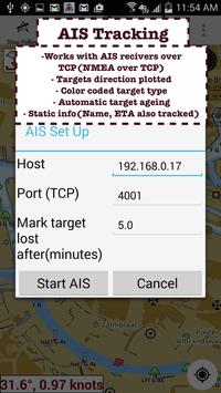
Marine AIS
MAPS
All details of your marine chartplotters!
Unlimited updates for 1 year.
USA: Maps incl coverage of all NOAA marine charts,ENC,USACE inland river maps & freshwater lake bathymetry maps for more than 20 lakes. Charts incl HD/1ft/3ft bathymetry for selected lakes. Incl NOAA marine charts(rasters) where NOAA ENC coverage isn't available.
Canada: CHS data Incl Great lakes(US & Canada sides),Alberta & Ontario lakes,Lake Simcoe&Trent Severn Canal,Quebec reservoirs.
U/Ireland: UHO marine charts
Germany:BSH charts,Waterways & rivers.
France
Europe Inland Rivers:Donau/Danube/Dunaja,Rhine,Rhein,Garonne,Moselle,Drava,Sava
Australia
Netherland/Holland
Croatia
Finland
Norway
Sweden
Russia
Ukraine(Black Sea)
Brazil
Spain
Malta,Cypress & Mediterranean Sea
Caribbean
New Zealand
Denmark,Greenland,Faroe
Seychelles,Mauritius,Tanzania
Falklands
Malaysia,South China Sea
Persian/Arabian Gulf,Red Sea
South Africa
Argentina
Iceland
Fiji
Estonia,Latvia,Poland,Lithuania
Turkey,Greece,Italy
-Instrumentation
Marine AIS & (NMEA AIS and GPS over TCP/UDP)
Wind direction & Speed,Marine Sonar depth,Water temperature
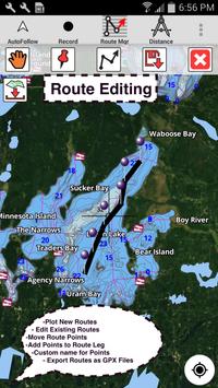
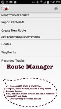
-ROUTE MANAGEMENT / TRIP PLANNING
Create/Edit/Reverse Boat Routes
Waypoints mgt
Import GPX,ML & MZ files
Share/Export Routes,Boating log, Tracks&Markers
-FEATURES for BOAT NAVIGATION
Auto Follow
- Real Time Overlay & Predicted Path Vector
- Course Up
- Speed & Heading
Route Assistance With Voice Prompts
- approaching boating route marker prompt
- Real time nautical distance & ETA
- sailing/boating off route/wrong direction
Record Tracks
-TIDE & CURRENTS
- High/Low Tides
- Tidal Current Prediction
- Active Current Stations
SHARING
- Sharing of tracks/Boat routes/markers/Waypoints
- Export GPX files.
Change background to Satellite Imagery
USA Marine Charts
- Texas Lakes: Texoma,Eufaula,Toledo Bend
- California Lakes:Tahoe, Shasta
- Pennsylvania Lakes: Lake Raystown
- Florida Lakes: Lake Okeechobee,issimmee
- Minnesota Lakes: Lake Minnetonka,Waconia,Leech,Mille Lacs
- Massachussets lakes Quabbin
- Missouri Lakes: Truman
- Ohio Lake maps of Lake hoover
- Wisconsin Lakes: Lake Winnebago,Pepin
- Utah Lake Powell,Bear
- Maine Lake Sebago
- Alaska Lakes: Lake Winnipesaukee
- Tennessee Lake Barkley,Norris,Watts Bar
- South Carolina Lake eowee,Hartwell,Murray
- Lake Michigan,Huron,Ontario,Superior,Erie
Canada Lakes Maps
- Lac Saint Jean
- Lake depth maps of Ontario Lakes
- Rideau Canal-Ottawa River
- British Columbia Marine Charts
- Pacific Coast-Vancouver- Haida Gwaii
- Nova Scotia South- Bay of Fundy
- Quebec to Anticosti Island
- Newfoundland
- St. Lawrence river
- Manitoba & Saskatchewan
- Georgian Bay
- Puget Sound
U Nautical Charts
- Scotland
- Thames Estuary
- Ireland
Australia Marine Chars & Lake Maps
- NSW
- Queensland
Conclusion
To conclude i-Boating:Marine Navigation Maps and Nautical Charts works on Android operating system and can be easily downloaded using the below download link according to Freeware license. i-Boating:Marine Navigation Maps and Nautical Charts download file is only 21.9 MB in size.i-Boating:Marine Navigation Maps and Nautical Charts was filed under the Tourism category and was reviewed in softlookup.com and receive 5/5 Score.
i-Boating:Marine Navigation Maps and Nautical Charts has been tested by our team against viruses, spyware, adware, trojan, backdoors and was found to be 100% clean. We will recheck i-Boating:Marine Navigation Maps and Nautical Charts when updated to assure that it remains clean.
i-Boating:Marine Navigation Maps and Nautical Charts user Review
Please review i-Boating:Marine Navigation Maps and Nautical Charts application and submit your comments below. We will collect all comments in an effort to determine whether the i-Boating:Marine Navigation Maps and Nautical Charts software is reliable, perform as expected and deliver the promised features and functionalities.Popularity 10/10 - Downloads - 28 - Score - 5/5
Softlookup.com 2026 - Privacy Policy
| Category: | Tourism |
| Publisher: | Gps Nautical Charts |
| Last Updated: | 02/03/2022 |
| Requirements: | Android 4.0+ |
| License: | Freeware |
| Operating system: | Android |
| Hits: | 1091 |
| File size: | 21.9 MB |
| Name: * |
E-Mail: * |
| Comment: * |
|