In depth
A closer look at UTM Geo Map
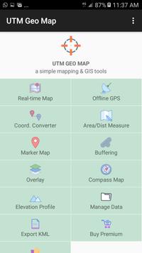
Get Latitude Longitude, UTM WGS 84 & MGRS coordinates from GPS / Map in real time. Create marker / marking point and save coordinates data into database, copy all marker data to clipboard or export to ML, GPX or CSV.
- Measure multiple marker complete with unique ID, coordinates (latitude longitude, UTM & MGRS), address, elevation msl (premium), editable notes / labeling & date taken. This data can be stored in local database with unlimited numbers, use as source data for analysis (buffering, overlay & TIN data) or export to ML, GPX or CSV and save to your local drive for further use.
- Offline GPS with Latitude Longitude, UTM & MGRS Coordinates, Altitude, Elevation MSL, Accuracy, Speed, Bearing & Satellite Information.
- Convert Latitude & Longitude (dd & dms) to UTM (WGS 84) & MGRS vice versa. Share, save to database, save to clipboard or show results on the map.
- Batch converter from Latitude Longitude and MGRS Coordinates.
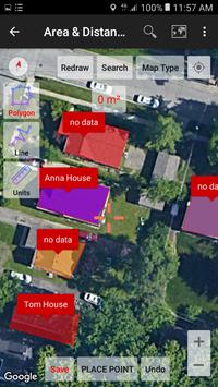
- Area & distance measurement (support units: m, km, ft, mile, hectare, acre), save line / polygon & area / distance results in database. Show multiple polygon and line in the map, export line & polygon to ML, GPX or CSV. Perform smoothing, buffering & overlay for simple GIS analysis. Auto generate polygon from marker data using Convex Hull, split polygon by line / polyline, delete marker inside or outside polygon, snap nearest object. Option to change line / polygon background color. Show label for each line / polygon: ID, custom note / label or area / distance value.
- Sophisticated & customizable Line & polygon smoothing using cubic bezier interpolation in Area / Distance measurement, design for collecting linear data to use in buffering & overlay analysis.
- Buffering: Create buffer map polygon with specific distance from existing marker (fix or variable buffer) or line & polygon from A/D measurement data (also support for negative buffer). Save buffer in database or export to ML, GPX or CSV.
- Buffer overlay tools for simple GIS analysis (union, intersection & difference).
- TIN view (triangulated irregular network, using delaunay triangulation), Voronoi Diagram, Convex Hull, Fix Buffer & Variable Buffer view in Marker Map module.
- Save geometry (Delaunay Triangulation, Voronoi Diagram, Convex Hull, Fix Buffer, Variable Buffer) to ML file and stored in local drive.
- Search for location on the map based on Latitude Longitude / UTM / MGRS / GPS coordinates / Marker ID / Address.
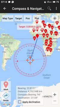
- Calculate bearing / azimuth & distance between 2 Latitude Longitude / UTM / MGRS / GPS coordinates.
- Compass with geodetic & magnetic azimuth / bearing & magnetic declination.
- Geocoding & reverse geocoding (convert address to coordinates & convert coordinate to address). This premium process needs internet connection.
- Elevation profile / elevation chart, support units metric & ft/mile from manual measurement, using available markers or auto generate route. Get free elevation for each measure markers.
- Load ML & GeoJSON file as a reference. Import CSV file (marker data).
Elevation (needs data / internet connection) now available to buy on premium section. Every marker measured and coordinate converter results (except batch converter) will be completed with elevation data.
Free option to get MSL elevation with lower accuracy are available using Offline GPS, this elevation is base on EGM 96 15' Geoid model.
Requirements
Device requirements
Android 4.1+
Verdict
Should you install UTM Geo Map?
UTM Geo Map is an Android application available under the
Freeware
license — the APK is 7.5 MB.
We’ve catalogued it under
Navigation.
✓
Verified clean. Every UTM Geo Map APK on SoftLookup is scanned for malware, spyware, and adware. We re-test on every update.
Sponsored
At a glance
UTM Geo Map specifications
- Publisher
- Y2 Tech
- Last updated
- May 5, 2026
- Requirements
- Android 4.1+
- License
- Freeware
- Operating system
- Android
- File size
- 7.5 MB
- Price
- Free
- Page views
- 857
Sponsored
Help fellow users decide. Share your experience with UTM Geo Map.